Difficulty
Difficult
Distance
102,0 km
Duration
6 days
Height difference
3439 m
Municipality of departure
LODEVE
Municipality of arrival
LA SALVETAT-SUR-AGOUT

Pedestrian
This route connects Lodève to La Salvetat-sur-Agout through the varied landscapes of the Haut-Languedoc. The route alternates between valleys, forests, high-altitude terrain, and charming villages such as Lamalou-les-Bains and Douch, before reaching the ridges and vast wooded areas of the Espinouse. A challenging hike between the Lodévois region and the mid-mountain terrain.



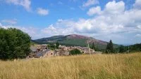



This hiking trail connects Lodève to La Salvetat-sur-Agout through the contrasting landscapes of the Haut-Languedoc, from the rolling hills of the Lodévois to the more rugged terrain of the Caroux Massif and the Monts du Somail. The route alternates between valleys, forests, ridges, and high-altitude plateaus, passing through charming villages such as Lamalou-les-Bains and Douch.
As the route progresses, it gradually gains elevation, offering sweeping panoramic views of the Orb and Jaur valleys, before reaching the forests, moors, and lakes of the La Salvetat-sur-Agout area. The route also passes through part of the UNESCO Global Geopark “Terres d’Hérault,” renowned for the richness of its geological heritage and the diversity of its landscapes. A challenging yet gradual hike through the heart of the Haut-Languedoc Regional Nature Park.
Difficult
102,0 km
6 days
3439 m
LODEVE
LA SALVETAT-SUR-AGOUT


