Contact
Address
Les Plans
Mairie
Place de la Mairie
34700 Les Plans
GPS coordinates : 43.7530268 / 3.2755932

Villages
Les Plans, a hilly village at the foot of the plateaus, combines ancient heritage and fertile agricultural land.

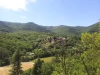

The municipality of Les Plans reveals itself at the heart of a steep and hilly landscape, between limestone hills and fertile soils. Frequented by humans long before our era, the territory quickly became regarded as a strategic space due to its geographical location, at the foot of the plateaus of Escandorgue and Grézac, close to the pass of Perthus and the city of Lodève. Crossed by the Soulondres, the village has fertile land that has developed an agricultural economy. Rich in historical, geological, and religious heritage, one notices the presence of various remnants from past centuries such as a dolmen on the heights of Les Plans or the Saint-Sauveur chapel in pre-Roman style.
Saint-Saturnin Church
and its funeral stone from the 5th-6th century
Saint-Sauveur chapel
and its ornamental paintings
The Dolmen
Les Plans
Mairie
Place de la Mairie
34700 Les Plans
GPS coordinates : 43.7530268 / 3.2755932


